TroutRoutes vs FlyFishFinder
Both apps have detailed trout stream mapping. FlyFishFinder goes past trout, with 220,000+ rivers for bass, carp, musky and steelhead in all 50 states, plus live flows, a daily top 10 near you, hatches and a bite forecast.
FlyFishFinder is a small, independent company. No venture capital and no big corporation behind us, so we move fast and build what anglers ask for. TroutRoutes is owned by onX.
Prices and features from each app's own listing, checked November 21, 2026.


- 220,000+rivers fully mapped
- 450M+acres of public land
- 10,000+live gages, free
- 380+river trip guides
The short version
-
Pick TroutRoutes if
You only fish trout streams in one state, never cross a state line, and want the cheapest single-state plan.
-
Pick FlyFishFinder if
You fish more than trout, or want to know where to go today. 220,000+ rivers in all 50 states, with species by river. A free top 10 of rivers near you by flow, and Top Rivers in Pro, which adds water temp and weather. A bite forecast and hatches with fly suggestions. Flows and water temp are free.
4.9 on the App Store
See what you get
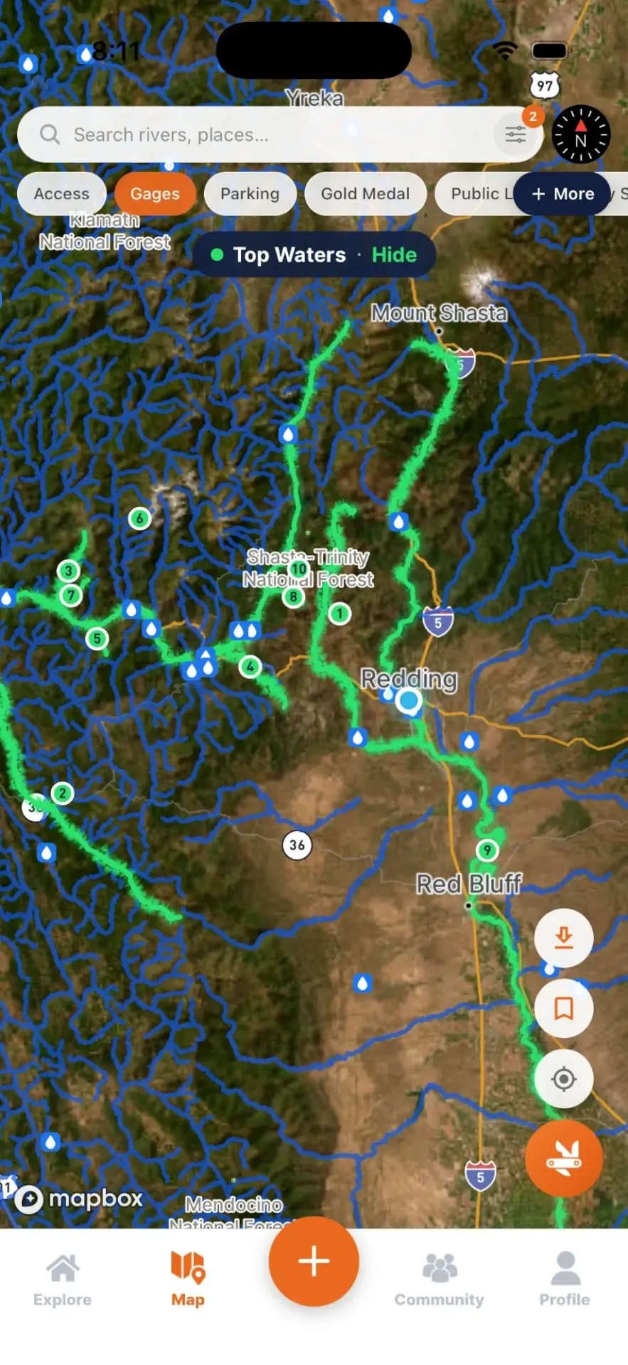
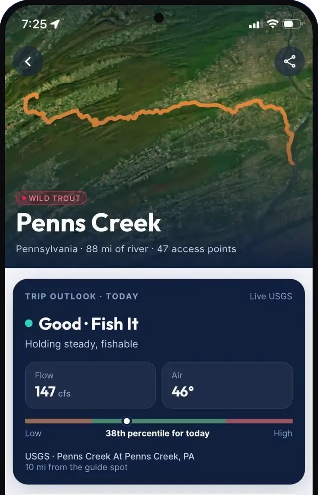
Two screens from FlyFishFinder. One tells you where to go right now. The other shows where you can legally get on the water.

Side by side
| Feature | TroutRoutes | FlyFishFinder |
|---|---|---|
| Trout stream mapping | Detailed, 50,000+ classified trout streams | Detailed, 55,000+ classified trout streams with state designations |
| Beyond trout | Built around trout streams | 220,000+ rivers for smallmouth, carp, musky, steelhead and coastal species |
| Species by river | Fish species filter in 9 western states | Brook, brown, rainbow, cutthroat, smallmouth and 100+ species mapped river by river |
| States covered | 48 (continental US) | All 50 |
| Price, all states | $39.99 a year or $9.99 a month | From $29.99 a year or $4.99 a month |
| Single state plan | $19.99 a year, map limited to the state you pick | Not needed. Every plan covers every state |
| Free version | Basic view of trout streams and limited features | Live flows, water temp, a top 10 of rivers near you by flow, and bridge access |
| Free trial | 7 days, then a year of Pro is charged unless you cancel | 7 days of Pro on sign-up with no card, then a 7 to 14 day store trial. Up to 3 weeks free |
| Live USGS flows | Yes, in Pro | Yes, free on 10,000+ gages |
| Water temperature | Not listed on their pages | Yes, free where the gage reports it |
| Rivers ranked near you | Not listed on their pages | Free top 10 by flow. Pro Top Rivers adds water temp, weather, wind and sky to show where and when to fish |
| Bite forecast | Not listed on their pages | Yes, when the bite should turn on near you |
| Hatches | Not listed on their pages | What is likely hatching from weather and water temp, with fly suggestions |
| River trip guides | Not listed on their pages | 380+ guides with access, Gold Medal stretches, easements and species |
| Public land | 360 million acres, plus private land boundaries | 450 million+ acres of BLM and National Forest, plus fishing easements, nationwide |
| Access points | 280,000+ hand-curated, incl. parking, camping, ramps and trailheads | Bridge access and USFS roads and trails free, plus wade spots, boat ramps, parking, campsites and trailheads |
| Map layers | Advanced filters and layer settings | 30+ layers and 6 base maps, incl. USGS topo, roads and satellite |
| River designations | Own trout stream classification | State designations like Gold Medal and Blue Ribbon on each river |
| Regulations | Yes, color-coded by section | Yes, in Pro |
| Offline Maps | Yes, in Pro | Yes, in Pro, with no storage cap beyond your phone |
| Logbook | Personal waypoints, notes and photos | Waypoints, saved rivers, fished log, river journal and catch cards |
| Route tracking | Not listed on their pages | Route tracer that works offline in your pocket |
| Angler community | Not listed on their pages | Free profiles and messaging to plan trips with other anglers |
| Fly shops | Yes | Yes |
| Desktop map | Yes | River guides and hatch charts on the web |
| Owner | onX (onXmaps, Inc.) | FlyFishFinder, LLC, independent |
Sources: the TroutRoutes App Store listing, troutroutes.com, the onX single-state announcement and the FlyFishFinder App Store listing, read November 21, 2026. "Not listed on their pages" means we could not find it on those pages, not that the app can't do it. Prices change and both apps run sales. TroutRoutes is a trademark of its owner. We are not affiliated with TroutRoutes or onX.
All fly fishing, not just trout
Both apps map trout streams in detail. TroutRoutes has its own trout stream classification. FlyFishFinder has 55,000+ classified trout streams with the state designations, like Gold Medal, Blue Ribbon and wild trout water, on each one. Where we go further is everything else. FlyFishFinder maps 220,000+ rivers in all, so smallmouth, carp and musky rivers are on the map, and so are steelhead runs and coastal water along the saltwater regions.
We also map species down to the river. Open a river and see if it holds brook, brown, rainbow or cutthroat trout, smallmouth bass, or one of 100+ other species. TroutRoutes lists a fish species filter too, in nine western states. Ours covers the whole country.
More data, all 50 states
Most anglers fish public water and easements. That is what FlyFishFinder maps, everywhere. Public land is nationwide, 450 million+ acres of BLM and National Forest, not just the ground next to trout streams. TroutRoutes lists 360 million acres.
On top of that you get fishing easements, bridge crossings, wade spots, boat ramps, parking, campsites, trailheads and trails across 220,000+ rivers. It all sits on 30+ map layers and 6 base maps, including USGS topo, roads and satellite, with the state's own designations shown on each river.
Real time, every time you open it
Both apps show live USGS gages. FlyFishFinder shows flow and water temp free on 10,000+ gages, then does the work for you. The free version ranks the rivers around you by flow compared with history and gives you a top 10 list of where to go. Pro adds Top Rivers, which also weighs water temp, weather, wind and sky to show where and when to fish.
The bite forecast reads the weather around your location and estimates if and when the bite should turn on. Hatches work the same way. The app looks at weather and water temps to show what is likely hatching, with bug and fly suggestions, on most of our rivers. Neither the TroutRoutes App Store page nor its homepage mentions water temp, hatches or a bite forecast.
Trip guides for 380+ rivers
FlyFishFinder has trip guides for 380+ major trout rivers. Each one is built on our own data, like access points, Gold Medal stretches and easements, plus research on what species live there. You can read them free on the web at flyfishfinder.com/rivers and open the same river in the app.
Your fishing log and community
Save waypoints and rivers, mark a river as fished and keep a journal for each river. Turn a catch into a catch card. Switch on the route tracer, put your phone in your pocket with no signal, and see later exactly where you fished. Offline Maps cover the spots with no service.
Angler accounts are free too. You get a profile and can message other anglers to plan trips together. It is new and still growing, but it is there.
Price
TroutRoutes Pro is $39.99 a year or $9.99 a month. FlyFishFinder Pro starts at $29.99 a year or $4.99 a month for every state. Our price can change while we test plans, so check the App Store for what you will pay today.
TroutRoutes also sells a $19.99 single-state plan. It sounds good at first, but the map is limited to the state you pick. Rivers cross state lines, and plenty of good water sits right on a border. We skipped state plans on purpose. One low price gets you every river in every state, with nothing cut off at the line.
The bigger difference is what you get for $0. The free TroutRoutes plan is a basic view of trout streams. Its 7-day Pro trial runs through the app store. FlyFishFinder gives every new account 7 days of Pro with no card needed. After that you can start a 7 to 14 day store trial, so many anglers get two to three weeks free before paying anything. Live flows, water temp, a top 10 of rivers near you by flow, and bridge access points stay free.
Try it free before you pay for anything
See live flows and the top 10 rivers near you by flow right now. Every new account gets 7 days of Pro, no card needed.
Common questions
Is FlyFishFinder free?
Yes, free to download, and the free features never expire. Every new account also gets 7 days of Pro with no card needed. Live USGS flows, water temp, a top 10 of rivers near you by flow, bridge access, and US Forest Service roads and trails are all free. Pro starts at $29.99 a year and adds public land, wade spots, regulations, Offline Maps and Top Rivers.
Which app is better for fly fishing?
If you only fish trout streams, both have detailed trout stream mapping. If you fish for anything else too, FlyFishFinder maps 220,000+ rivers for trout, smallmouth, carp, musky, steelhead and coastal species, with species shown river by river in all 50 states.
Does FlyFishFinder show hatches and where to fish today?
Yes. It shows what is likely hatching from weather and water temps, with fly suggestions, plus a bite forecast and a live list of the best rivers near you. It updates every time you open the app.
Does FlyFishFinder work without cell service?
Yes. Offline Maps save the map for spots with no signal, with no app limit on how much you save beyond your phone storage. And the route tracer records where you fished even with your phone in your pocket.
How much does TroutRoutes cost?
TroutRoutes lists Pro at $39.99 a year or $9.99 a month, and a Single-State plan at $19.99 a year. Their App Store page also shows other prices, like $58.99 a year, without saying who gets them. Prices and sales change, so check their page before you buy. These numbers were read on November 21, 2026.
Is TroutRoutes owned by onX?
Yes. The TroutRoutes App Store listing names onXmaps, Inc. as the seller. FlyFishFinder is a separate, independent company.
How do I cancel a TroutRoutes subscription?
If you subscribed on an iPhone, open Settings, tap your name, then Subscriptions. On Android, open the Google Play app, tap your profile, then Payments and subscriptions. Cancel before the 7-day trial ends if you do not want to be charged for a year.
Which app has more public land?
FlyFishFinder lists 450 million+ acres of BLM and National Forest land, mapped nationwide. TroutRoutes lists 360 million acres. Both apps map fishing access, and FlyFishFinder adds easements, campsites, trailheads, and free US Forest Service motorized and non-motorized roads and trails nationwide.